October 30, 2012

More details emerge from bee attack that ended in the death of one hiker


About 3:45 p.m. on Monday, October 29, 2012, emergency crews received a call from a hiker who had witnessed another hiker fall about 150 feet after trying to swat away a swarm of bees, according to a report by The Arizona Republic.


Echo Canyon Trail - Chiricahua National Monument
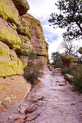
Echo Canyon Trail - Chiricahua National Monument (Photo credit: Al_HikesAZ)
Joshua R. Ruzsa, 19, was hiking with his two friends near George’s Route and Icebox Canyon just off the popular hiking trail, Echo Canyon. When they began to climb up a steep wall, the bees began stinging the men. Rusza tried to climb to the top of the mountain to get away but lost his footing and fell to his death.

The other two hikers, about the same age as Ruzsas, found a nearby alcove in the mountain and covered their faces from the bee attack, according to the report. They curled up to try to protect themselves from the swarm, according to local officials, but were both stung at least 300 times each.

A helicopter brought rescuers, and one wearing a bee suit was lowered from the helicopter. He found the men curled up in the fetal position with bees swarming around them. The rescuer attached one man to the rescue bag that hoisted him up into the helicopter. The rescuer then remained below to care for the second hiker. The rescuer suffered several bee stings to his wrist and ankles.

He gave the second victim an EpiPen to stop the swelling , then placed a black bag over the man’s head to prevent more bee stings. Both victims were flown to the base of the Echo Canyon trail where rescue crews waited to transport them to a nearby hospital. Both are recovering from their injuries.

Officials said that bees live in the mountains and it is common for them to swarm if anyone kills or swats another bee. Officials encourage hikers to stay on trails and follow trail signs.
Enhanced by Zemanta

Odds slim of being attacked by a bear in the Oregon wild (there’s only been four instances) - but possible


Years ago, while sitting along the shoreline of the westernmost Twin Lake in the Bull of the Woods Wilderness, I was asked by three gun toting strangers if I was carrying. After answering “no,” I quickly realized it was a mistake. With side arms holstered like Audie Murphy, their next question, however, relieved me of all my concerns. “Well, what if you run into a bear?” one asked.

Hiker’s death from fall prompted by bee attack


October 30, 2012 - A bee attack caused a hiker to fall 150 feet off a cliff at recreation area in Arizona. The man was pronounced dead at the scene in the Echo Canyon area of Camelback Mountain.

Two other hikers were airlifted out after each was stung about 300 times, according to reports. Paramedics said both men were hospitalized in serious but stable condition and expected to recover.

Three men were attacked by bees on a trail near Ice Box Canyon. The two survivors apparently hid in a sheltered area to get away from the bee swarm until they were rescued.

October 29, 2012

Hiker in the Sierras located after four days in the mountains

October 29, 2012 - One of two men lost in California’s eastern Sierras during the last week, Matthew Hanson, has been located alive, according to KSEE 24 News.

Monday afternoon shortly before 3:30 p.m., H40, the CHP helicopter, discovered shoe tracks in the area of Cathedral Lake. Hanson then walked out to the open so he could be seen by the helicopter.

H40 was able to land nearby, and Hanson was able to walk to them. His condition appeared to be initially good.

Cathedral Lake is at an elevation of about 10,800 feet, and is within the original 130 square mile search area.

Teens lost near Table Rock Wilderness found in good condition


Jackson Chandler, 17, and Bradley Nelson, 16, two teens lost in the Cascade Mountains near the Table Rock Wilderness over the weekend, were found Monday afternoon.
They left their homes in West Linn to day hike in the Table Rock Wilderness area Saturday afternoon and did not return. According to reports, about 50 people searched for them on Monday, aided by an Oregon Air National Guard helicopter.

The pair did not need medical attention when they were located at about 2 p.m. Monday.
Both boys are in the Boy Scouts, have multiple outdoor and survival skill merit badges and are working on becoming Eagle Scouts, a family spokesperson said. It was their first hike into the Table Rock area.

Hunters found the boys' truck Sunday afternoon along the side of the road near the Lost Creek Meadow area about five miles east of the Table Rock Wilderness.
Enhanced by Zemanta

Mt. Everest part of new national park in Tibet

English: Mount Everest North Face as seen from...
English: Mount Everest North Face as seen from the path to the base camp, Tibet. Español: Cara norte del Monte Everest vista desde el sendero que lleva al campo base en el Tibet (China). Français : Face nord du Mont Everest vue du chemin menant au camp de base. Tibet. Italiano: Faccia Nord del monte Everest vista dal sentiero che porta al campo base in Tibet. (Photo credit: Wikipedia)
October 29, 2012 - The highest National Park in the world was opened October 26, 2012, in Tibet. The park’s name is Qomolangma National Park, which is the local name for Mt. Everest.

Within the park, five mountains reach more than 8,000 meters (26,246 feet), the tallest being Everest at 8,848 meters (29,029 feet). It has 10 mountains that rise above 7,000 meters (22,966 feet).
The new park covers 78,000 square kilometers (30,116 square miles and six districts of Tibet's Shigatse region. It also borders Nepal.
Enhanced by Zemanta

October 28, 2012

Teens missing in Table Rock area east of Molalla

October 28, 2012 - Clackamas County Search and Rescue teams are searching for two missing teens in the Table Rock area, east of Molalla.

The two West Linn High School students have been missing since 3:30 p.m. Saturday after they went for a day hike at Table Rock, located in the Molalla River Corridor.

The search started Saturday night and is continuing with around 50 personnel on scene.

Searchers have located their vehicle, a gold 1999 Mazda pickup east of Table Rock.

October 27, 2012

Wet wood in the wild no match for this fire system


Calvin "the Wonder Dog" along the shore of Lower Lake

As most folks know, the key to any good fire is dry wood. Without it, building a fire is like picking a banjo with no strings. Time spent in the woods has allowed me to utilize a campfire system that builds a toasty fire, even when rains or snows have soaked a forest’s wood.

October 26, 2012

Views from Little North Santiam River Trail a must see

Little North Fork Santiam River

I doubt if there could have been a better day to stroll along the Little North Santiam River inside the Opal Creek Recreation Area. This 4.5 mile trail meanders along the beaches and benches of the river's shoreline, climbs steeply above the roar of its turbulent stretches and emerald pools to views overlooking its narrow gorge, Henline Mountain, and Triple Falls. 

October 24, 2012

Virtually climbing Mt. Everest? Not only is it possible – it is likely!

Like it did with its street-view cameras, Google is about to open up some of the Grand Canyon's hiking trails to its viewing audience. With cameras mounted to backpacks, Google employees are hiking into the canyon to photograph its splendor and the hike itself.
Early Monday, Luc Vincent, Google engineering director, strapped on one of the 40-pound backpacks and hiked down the Bright Angel Trail to the Colorado River, a nearly 10 mile hike that drops from 6,900 feet in elevation to 2,400 feet. He hiked back up from Phantom Ranch through the South Kaibab Trail and also gathered data on other trails.
The trekker, the apparatus that takes the pictures, captures images every 2.5 seconds with 15 cameras that are 5 megapixels. A removable hard drive on the trekker stores the data gathered at the Grand Canyon.
Hikers that were on the trail when the data was gathered will have their faces blurred to ensure privacy.
With a click of the mouse, Internet users are transported virtually for a 360-degree view of locales they may have read about only in tourist books and seen in flat, 2-D images.
The backpacks aren't ready for volunteer use, but Google has said it wants to deploy them at national forests and even Mount Everest.
Google launched its Street View feature in 2007 and has expanded from five U.S. cities to more than 3,000 in 43 countries. Google teams and volunteers have covered more than 5 million miles with the Street View vehicles.

"Messing around" on trail lands two men in the pokey

October 24, 2012 - A Provo, Utah, man will spend 30 days in jail after he and a friend placed booby traps along a hiking trail. He also must serve 18 months of probation, according to a Salt Lake Tribune report. The man's friend was sentenced last week to spend 20 days in jail and complete a year of probation.

English: Provo Canyon, Fall 2006.
English: Provo Canyon, Fall 2006. (Photo credit: Wikipedia)
According to court documents, the two men built two traps around a manmade shelter near the Big Springs trailhead in Provo Canyon. One trap was a suspended ball of rocks and sharpened sticks made to swing at face level when a trip line was triggered. A second trip wire was set to cause someone to fall on sharpened sticks protruding from the ground.
A Forest Service officer noticed the traps while patrolling the area.
One of the men's attorney said, "They were just messing around, and it was just a stupid decision. When he realized and thought about it, he went up there and tried to disable the devices but by that time the ranger had taken them down. I don’t think they ever really intended anybody to get caught in the thing. It was more games, capture the flag and military type stuff. Just a couple of boys messing around."
The Forest Service officer said the traps "could cause significant or lethal" injuries, court documents state.
Enhanced by Zemanta

October 23, 2012

Sheer-face rescue on El Capitan keeps climber from suffering severe hypothermia


October 23, 2012 - Yosemite National Park Rangers and Search and Rescue Personnel completed high risk rescue on El Capitan, the largest granite monolith in the world, in Yosemite Valley, on Monday, October 22, 2012. A stranded Canadian climber was at risk for hypothermia, according to a KMPH-TV report.
El Capitan
Two rock climbers began ascending a climbing route, known as the Muir Wall, on El Capitan on Monday, October 14, 2012. The party was due to reach the top of the climb on Sunday night, October 21, just before a large storm was forecast. The lead climber, a 24-year old male from Ontario, Canada, reached the summit just before midnight on Sunday night.

The second climber, a 40-year old male from British Columbia, Canada, was forced to spend the night approximately 230 feet below the summit due to impending bad weather and a stuck climbing rope. He was unable to properly erect the rainfly on his portaledge (tent system). During the night, the area received approximately four to six inches of snow with nighttime temperatures in the mid-twenties.

Yosemite Park Rangers were notified of the possible hypothermic climber midday on Monday, October 22. Due to unfavorable weather, the park could not use a helicopter to assist in the rescue and instead deployed ground teams. Park Rangers and rescue crews hiked to the summit of El Capitan to rescue the climber. The team rigged anchors and immediately began lowering Park Ranger Smith approximately 230 feet to the climber. Upon arrival, Smith found the climber to be suffering from exhaustion and mild hypothermia. Smith attached ropes to the climber, and then ascended the ropes back to the summit. Using a mechanical advantage system of pulleys, the team was then able to hoist the climber to the summit.

After warming the climber, the team descended back to Yosemite Valley via hiking and rappelling. The climber was transported to a local hospital and is in good condition.

Tis the season for hypothermia

A recent news piece regarding a woman found in the Mt. Jefferson Wilderness along the Pamelia Lake trail with hypothermia is a reminder that temperatures are dropping, most severely in the mountains. In this particular instance, the woman had taken off some of her clothing in response to her body cooling. Although it doesn’t seem to make any sense, this is a symptom of hypothermia and has been observed in other cases. Here is a quick piece on how to recognize and treat hypothermia.

Hypothermia is defined as having a core body temperature less than 95 degrees F or 35 degrees C. It most often occurs because of prolonged exposure to cold weather.

Shivering is the body's automatic defense against cold temperature, as it attempts to warm itself. It is one of the symptoms of hypothermia. Other symptoms include clumsiness or lack of coordination, slurred speech, confusion, poor decision making (i.e. removing clothes), drowsiness, apathy, loss of consciousness, weak pulse and shallow breathing. People with hypothermia often do not know what they are suffering from because of their confused state.

According to WebMD, treatment for hypothermia includes restoring warmth slowly. This is done by getting the person indoors and removing any wet clothing. If wet, dry the person off and warm their trunk first (warming extremities first can cause shock). Wrap the person in blankets or put dry clothes on them.

Do not immerse the person in warm water. Rapid warming can cause heart arrhythmia. If using hot water bottles or chemical hot packs, wrap them in cloth; don't apply them directly to the skin. Begin CPR, if necessary, while warming the person.

Give the person warm fluids if they are conscious, but not coffee or alcohol. Finally, keep them warm and seek medical treatment.
Enhanced by Zemanta

October 22, 2012

Lost woman with hypothermia found near Pamelia Lake


October 22, 2012 - A 61-year-old Salem woman, Lynette Gail Cubic, who got lost in the Mt. Jefferson Wilderness on Sunday, was found alive but incoherent and suffering from advanced hypothermia Monday morning, according to KVAL News.

Rock Lakes Basin a welcome rarity in the Mt. Hood area

Serene Lake from Viewpoint

Lake Basins make some of the best destinations for a hiking or backpacking trip, especially if you like to cast a line in search of a brook or rainbow trout. A typical lake basin, at least by name, usually contains several lakes. Side trails to the lakes make for great day hikes from a base camp. Unfortunately, compared to other regions in the Cascades of Oregon, these lake basins are woefully lacking around the Mt. Hood area.
 

Bear in the proximity of Timothy Lake teases then vanishes

Winter time at Timothy Lake

It was the early morning when I left the small camp located lying along the north end of Timothy Lake and hooked up with the PCT near the intersection with the trail to Little Crater Lake, a small but deep, turquoise pool created from springs. From there, I intended to hike the Pacific Crest Trail to its intersection with road 58. I eventually had to cut the hike short because of a rare sighting that begged for a great deal more attention.

I can't honestly say whether it was movement caught out of the corner of my eye or if I just happened to look in that direction. Either way, the movement was that of a large animal which, I would like to believe was observed as a result of keen awareness of my surroundings, developed over time in the wilds. After spending a lot of time in the woods, senses sharpen and a feel for one’s surroundings matures.

 Then again, it was probably just dumb luck that I spotted the bear.

October 21, 2012

Review of grizzly bear protocol expected soon


Grizzly bear and cub in the Shoshone National ...
Grizzly Bears


In a recent report from Montana’s The Missoulian, a protocol review was done in response to the increase of grizzly bear activities in the six national forests surrounding Yellowstone. Apparently, grizzly bear populations in Yellowstone National Park have expanded, prompting the supervisors of the national forests surrounding the park in Montana, Wyoming and Idaho to take more precautions.

October 20, 2012

Sampling the hazards of driving mountain roads near Badger Creek Wilderness


Mt. Rainier and Mt. Adams standing over the fog of the valley from Divide Trail
 
 It was fall and the Divide Trail in the Badger Creek Wilderness was my destination. As I drove to the trailhead, the sun appeared and began its daily climb in the sky. Cruising along road 4410, two does popped their heads out of a cluster of trees hugging the road. A mile further, two more does bounced out of a thicket and bounded directly toward the front of my pickup. While tapping my breaks, they quickly detoured and bounding parallel with the road as if they wanted to race me. It was another reminder of the need to remain vigilant while traveling the network of roads in these mountains.


October 19, 2012

How to remain involved with hiking when the rains start falling

It was such a nice fall through September and early October. Then, like the leaves, it all started to turn. The first rains in many weeks finally hit Oregon and you know, if you've lived in the state for any length of time, the rains will fall for a while - until June.

So now, unless you're a hardcore hiker and don't mind hiking in blustery weather, you're forced to keep an eye on the weather and sneak in a hike whenever the sky isn't falling.

When moisture is in the air and you don't want to get wet, but you want to stay somewhat in contact with the outdoors, grab a map and plot out where your next hike will be. I often find that planning a backpacking trip or scouting out a hike by simply looking at maps is a lot of fun. But then again, I have this thing about maps and charts and graphs and such.

Something else I'll do is simply get on the internet and look at outdoor pictures. On a day when the rain is coming down sideways, there's not a lot of things better than looking at sunny, Cascade Mountain scenes.

Another way to pass the time is to go on You Tube and find some of the newest ideas in hiking and backpacking. Here, you can find ultralight backpacking tips (if you're into such a thing), learn how to make a backpack stove out of a beer can and find out how to catch a squirrel if you run out of stuff to eat in the wild.

Another option is to head to the nearest outdoor store and spend some time looking at all the goodies. I'm like my daughter at the mall when I'm in one of these places. In Portland, one of the best outdoor stores in the city is next to a bicycle shop which is next to a army surplus store. Now that is my idea of mall shopping.

Learning its all about the quest in the Southern Oregon Cascades


Rainbow over Fourmile Lake
My bride and I set up camp at Fourmile Lake, located 6 miles off Highway 140 along the crest of the Cascade Mountains in Oregon. Monday morning, unforgiving winds whipped up waves and sent them crashing against fallen tree snags lining much of the shore. Gathering strength as the day progressed, the gales stirred the water into a sea of whitecaps. Later that evening, I paddled out into the calming waters in search of trout, but caught nothing. If not for the fantastic view of Mt. Mcloughlin and the commitment to meet my parents at the lake later in the week, we would have packed up and camped elsewhere. I had one big goal that week, and it didn't matter where in the Cascades it occurred, just as long as it happened.

Monday morning I began the 5 mile hike and climb to the summit of 9,495' Mt. Mcloughlin. The trail meandered through the forest for awhile and gradually steepened, snaking along the mountain's east ridge. Eventually, the number of trees along the trail thinned and the summit of the mountain could be seen. At the top, I stood alone, save for a couple water bottles carelessly left behind by some hikers. The only other hints of anyone else were spray painted rocks and the ruins of a lookout. High clouds hovered above, affording me a view of Mt. Shasta; Fish, Fourmile and Klamath Lakes; Lake of the Woods, the Mountain Lakes Wilderness; and to the north Three Sisters.

October 18, 2012

Black bears force shutdown of North Carolina wild areas


October 18, 2012 - Shining Rock Wilderness and Graveyard Fields in North Carolina were closed Wednesday to camping for the first time in at least five years after seven black bear encounters with humans were reported to the U.S. Forest Service.

The Forest Service said in a news release that the agency will “monitor conditions to determine when it is safe” to open the areas back up to camping.

N.C. Wildlife Resources Commission Biologist Mark Carraway said an acorn shortage at higher elevations was a contributing factor to the recent emergence of the black bears. The acorn crop at the higher elevations wasn’t sufficient enough to feed the bears, which pushed them down to a more plentiful crop at lower elevations.

Yosemite National Park trail reopens after rockfall creating a magnitude 2.4 earthquake

October 18, 2012 - Yosemite National Park will reopen the Mirror Lake Loop hiking trail on Thursday, October 18, 2012, at 5:00 p.m. The five mile loop that follows Tenaya Creek around Mirror Lake in Yosemite Valley has been closed since March 28, 2009 due to a large rockfall from Ahwiyah Point near Half Dome.

Yosemite Trail Crews have constructed a new trail on the edge of the talus slope near Tenaya Creek.

Rocks fell approximately 1,800 feet to the floor of Yosemite Valley from Ahwiyah Point, knocking down hundreds of trees and burying hundreds of feet of the trail on the southern portion of the loop. The impact of the rocks hitting the ground generated a magnitude of a 2.4 earthquake. The rockfall was estimated to be approximately 43,000 cubic meters, or 115,000 tons. No injuries or structures were affected by the rockfall. Due to its steep, glacier-carved cliffs, Yosemite Valley experiences many rockfalls each year

October 14, 2012

Lost near Rooster Rock? Naahh. I prefer to call it “misdirected.”


Rooster Rock with Mt. Jefferson in background
Summer had withdrawn and autumn crept in, carrying a full bag of tricks as the weather is concerned. Early snow had already fallen on the Cascades as low as 4,000 feet, and I wanted to reach some jagged spires I had studied during the summer while exploring the area near Table Rock. In late October, Noia and I set out to explore the outcropping called Rooster Rock, named by a prospector in the mid-1800s.

October 13, 2012

Plenty of great viewpoints tower above Diamond Lake

Trail to the slopes of Mt. Thielsen on a smoky day
The greatest reward from climbing a mountain is the accomplishment. The second is the view from the summit. Frequently, when topping a Cascade volcano or one’s remnants in Oregon on a clear day, one can see the two sides of Oregon: green stretching as far as they can see to the West and more arid country to the East. Ridges radiate from mountains before flowing and spreading into forestlands. Still at altitudes of 5,000', those forestlands then eventually give way to flatlands of the Willamette Valley and the high desert of Central Oregon.


October 12, 2012

Want a workout? Try Mt. Defiance on for size

Near the summit of Mt. Defiance, looking down into the Columbia Gorge
Some mountain trails can be a true test of a person's stamina and ability to overcome physical distress. Forcing legs to scream and lungs to work like salmon swimming upstream, these trails can provide a yardstick to gauge one's physical condition. Usually these trails consist of a severe uphill grade that lasts a significant distance, providing a much different experience than a level hike of the same length. While some folks probably enjoy the challenge of these trails fairly regularly, I prefer to mix them into the schedule much, much less frequently.


October 9, 2012

Big cat scat on the trail evokes story of cougar attack

Cougar

While preparing for a day hike in the Cascades several years ago, my father asked me if I had heard about the woman in California attacked, killed, and partially eaten by a cougar. He went on to suggest that perhaps I should be extra careful when hiking alone. Apparently, the woman was jogging when the cat pounced on her. They found her body partially covered with debris after the cat had tried to hide it from other predators.

Aware that cougar attacks were more common in California, I listened to the piece of news with mild interest but brushed it off as a problem in California and something I needn't worry about.

Not more than a quarter mile into the hike, which would lead me from Squaw Mt. road to Old Baldy, a butte located in the Salmon-Huckleberry Wilderness, I ran across some rather large scat I knew was not from a deer or elk or bear.

I continued up and down the relatively uninspiring trail until I stopped near a trailside cliff offering a look at Mt. Hood to the northeast. As I continued toward Old Baldy and neared its namesake summit, I stepped near some deer hair that had clearly been through the digestive system of what I was now sure was a big cat. As I sifted through the litter with a stick, a white bone fragment about the size of a nickel appeared lodged in a chunk of dung. Suddenly I remembered the words of my father from a few days earlier concerning the California cougar.

I proceeded to the summit of Old Baldy that day and looked across the Salmon-Huckleberry Wilderness to Mt. Hood. This area was designated a wilderness in 1984. Over 70 miles of hiking trails run through its canyons and ridges.

After seeing the scat, as I hiked to the top of Old Baldy and back to the trailhead, the lock blade I usually carry in my pack for cutting an apple or sausage was open and gripped firmly in my right hand.


October 8, 2012

You can hear the echos of pioneer kids saying, "How long till we get there?"

Summit Meadow
After hiking the Pioneer Bridal Trail up Laurel Hill recently, I checked out a couple of easily accessible spots nearby where remnants of the Barlow Trail still exist. These sites are on or near the pass leading to Government Camp. Three of the spots are only a few steps from a parking area. The other site demands a short hike to see what must have been one of the, if not the most, daunting sections of the Oregon Trail.


October 7, 2012

Pioneer Bridal Trail exhibits strength, tenacity and toughness of those who journeyed west

A portion of the Barlow Trail
After having travelled along and ignoring various sections of the Barlow Trail virtually all my life, I decided recently to finally be a little more proactive in the pursuit of Oregon’s earliest history. After researching the trail, I drove up Highway 26 toward Mt. Hood. There, I discovered firsthand the tenacious determination the folks traveling over the trail possessed. The desire to leave everything behind in pursuit of a new life is one thing. The hardship they must have suffered while traveling along the trail is entirely another. This is what you realize when you experience the trail for yourself – seeing the unyielding longing these people had to go west and start a new life.

October 5, 2012

Morlocks discovered at Walton Lake

Walton Lake
During a week-long trip into Central Oregon, my bride and I ran into heavy rains in the Cascades, so we tried to skirt the bad weather by heading east and trying our luck in the Ochocos. We ended up at Walton Lake in the evening, unpacked in decent weather, set up camp, and crawled into the tent for the night. Little did we know that we had planted ourselves in the midst of a community of devil critters.


October 3, 2012

A high Cascades forum – the great stink box debates


outhouse
outhouse (Photo credit: twofordssearchin)
The plan was to begin our Labor Day weekend at Jack Lake, located on the southeast edge of the Mt. Jefferson Wilderness. The Bakers used such glowing adjectives to describe this tiny lake and the hike into nearby Canyon Creek Meadows, my bride and I wanted to experience the area for ourselves.